I often have to travel for work and I love exploring an area by running when work allows. The pace of running and the ability to explore small paths is a nice middle ground between walking and driving for getting the feel of a place.
I give a lot of weight to proximity. If running in the morning during a work trip I almost always have somewhere I have to be at a hard time. If running after work I have limited energy and time left to run, eat and close up work. The more time spent traveling the less time spent running. To this end in particular, a little research ahead of time can really make running while traveling a lot more rewarding given limited time.
I give a lot of weight to proximity. If running in the morning during a work trip I almost always have somewhere I have to be at a hard time. If running after work I have limited energy and time left to run, eat and close up work. The more time spent traveling the less time spent running. To this end in particular, a little research ahead of time can really make running while traveling a lot more rewarding given limited time.
Bringing on the Heat
The first place I go nowadays when researching running routes for travel is Strava's heat maps. For a while I thought this was a premium feature (only available to paying members) . . .
 |
| Well, nuts. . . |
Then my friend showed me how to access this cool feature for free. . . you first:
1. Got to My Routes
2. Select "Create New Route"
3. Click on the Settings wheel and
4. turn on Global Heatmaps
Voila! You instantly have the collective feedback of where hundreds of other runners most often go. Big popular routes show up nice and bold.
Safety
The fewer road crossings the better and I hate finding myself needing to connect a loop along a busy highway with a 55 mph speedlimit and a 1-ft shoulder. If I'm going to try to connect a loop that does not show some traffic on a heat map I like to check Google Earth to help me feel that I can safely run along the side.
For example, recently I wanted to take a run from my hotel. Strava shows some nice popular routes pretty close by but a worryingly less popular stretch in between.
Google Earth reveled that indeed this was not an overy pretty stetch
The Wisdom of Crowds
The next thing I like to check when traveling is searching for running groups. Often I do not have time for group runs before or after work, but when I do I find it really rewarding to run with other folks.
Other Resources
Map My Run and similar sites
If you just Google "Running routes in (some location)" you often get a lot of good websites that will suggest some routes. For general running routes of trails and roads I like Map My Run. The advantage it has over other popular sites (such as USATF routes and Runkeeper) is that you can easily search the routes on a map. Since I'm looking for runs based on where I'm staying or going to be this is more useful than a list of popular routes.
Map My Run also has the nice feature of being able to download routes and GPS or KML files.
The main caveat I have with these website is that they don't always give you a full pictures of all of the great options that are out there. They show a small percentage of a few uncurated routes that can give you some ideas. When I look at my local stomping grounds a lot of really good loops are just not there.
Trail Running
For trail running my favorite source of inspiration is REI's Trail Run Project. The nearby trails show up nice (and it seems to focus more on the dirt and single track trails) along with good filtering options.
Planning a Route
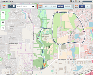
After getting inspiration from Strava and other sites I may still sometimes cobble together a route that fits my particular hotel or parking location. While Strava has a Route Planner I have found that it's adherence to roads and trails sometimes just does not match the physical reality of what I know I can do on the ground. In these cases I like to turn to Plot a Route. This site has the nice features of letting you turn tracking off or set it to roads or foot.
You can then save the route or (as I often like) export it as a GPX or KML file.
The Map is Not the Ground
After I first noticed the green space on Google Maps I looked up trail maps for Patapsco State Park online. The maps were great for getting the overall structure of the trail system and doing some basic route planning. But the disadvantages quickly became apparent when I started running. The maps only showed park roads and not rather convenient features like local roads and streams. The maps also did not all newer trails. |
| Without Will Surles showing me this trail I never would have found this cool loop |
Google Maps shows many trails but I have found Strava to have the most complete trail maps (although still not perfect). Below shows a fun connecting trail that I took after discovering it on Strava that did not show up on Google Maps.
 |
| Strava |
 |
| Google Maps |


